
Seattle to Los Angeles Drive: The Full West Coast Road Trip Guide
I’ve driven from Seattle to Los Angeles twice — once straight down Interstate 5 South in 2 long days, and once over 6 days along Highway 101 and the Pacific Coast. They were 2 completely different trips. The I-5 route got me to LA in 17.5 hours of total driving time. The Highway 101 coastal route took 25+ hours behind the wheel but gave me the Oregon Coast, the Redwoods, San Francisco, Big Sur, and some of the best scenery in the United States.
The Seattle to Los Angeles drive is approximately 1,135 miles via Interstate 5 South and takes about 17 hours of nonstop driving. The scenic coastal route via Highway 101 South and Highway 1 stretches to roughly 1,400 miles and takes 24 to 26 hours of driving. Plan 2 to 3 days for the I-5 route and 5 to 7 days for the coastal road trip. Both routes pass through 3 states: Washington, Oregon, and California.
This guide covers both route options in detail, the best stops on each, a realistic day-by-day itinerary, driving costs, seasonal conditions, and the honest trade-offs between speed and scenery. The Seattle to Los Angeles drive is one of the great American road trips — but only if you take it the right way for your schedule.
Seattle to Los Angeles Drive Distance and Time
The driving distance from Seattle to Los Angeles is approximately 1,135 miles via I-5 South, with a drive time of roughly 17 hours without stops.
That 17-hour number assumes no traffic, no weather delays, and no stops. In reality, you’re looking at 19 to 20 hours once you add gas, food, and the inevitable slowdowns near Sacramento and the LA metro area. Los Angeles traffic alone can add 30 to 60 minutes depending on the time of day you arrive.
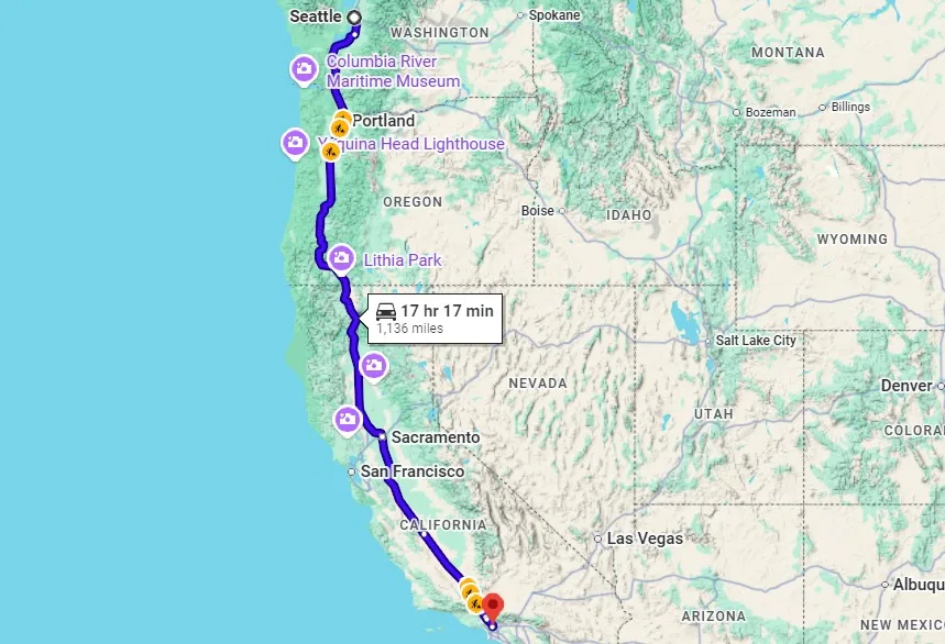
Seattle and Los Angeles share the same time zone (Pacific), so no clock adjustments to worry about.
Here’s the distance breakdown on I-5:
| Segment | Distance | Drive Time |
|---|---|---|
| Seattle to Olympia, WA | 60 miles | 1 hour |
| Olympia to Portland, OR | 115 miles | 2 hours |
| Portland to Salem, OR | 47 miles | 45 min |
| Salem to Medford, OR | 225 miles | 3.5 hours |
| Medford to Redding, CA | 150 miles | 2.5 hours |
| Redding to Sacramento, CA | 160 miles | 2.5 hours |
| Sacramento to Bakersfield, CA | 280 miles | 4 hours |
| Bakersfield to Los Angeles, CA | 110 miles | 2 hours |
Practical info:
- Main highway: Interstate 5 (I-5 South) for the entire direct route
- States crossed: Washington, Oregon, California
- Gas cost: Roughly $55 to $80 one-way (1,135 miles at 28 mpg, $3.50 to $5.00/gal depending on state)
- Best season: May through October for clear weather on all routes
- Tip: California gas prices are significantly higher than Washington or Oregon — fill up before crossing the state line near Medford. Getting a quote for car shipping costs in advance can help ensure a smoother journey home. Don’t leave it to the last minute; plan ahead for peace of mind!
My honest take: The I-5 route is not a road trip. It’s a drive. I-5 through Oregon’s Willamette Valley is flat farmland. I-5 through California’s Central Valley is flatter farmland. The stretch between Sacramento and Bakersfield is 4 hours of nothing. I did it straight through once and the only memorable part was the Siskiyou Pass at the Oregon-California border, where the Cascade Range drops away and Northern California opens up. If you’re in a hurry, I-5 works. If you want a trip you’ll remember, take the coast.
The 2 Best Routes from Seattle to Los Angeles
2 main routes connect Seattle to Los Angeles: Interstate 5 South (fast and direct) and Highway 101 South / Highway 1 (scenic coastal drive).
Route 1: Interstate 5 South (The Fast Route)
I-5 runs the entire length of the U.S. West Coast, from the Canadian border through Seattle, Portland, Sacramento, and into Southern California. It’s the most efficient way to cover the distance between Seattle and LA. You’ll pass through every major city on the West Coast — Olympia, Portland, Salem, Medford, Redding, Sacramento, and Bakersfield — before reaching LA.
The road is well-maintained, rest stops are frequent, and gas stations appear every 20 to 30 miles. The drive is functional, not scenic. Oregon’s stretch is the most pleasant (green, rolling hills). California’s Central Valley between Sacramento and Bakersfield is the least pleasant (flat, hot in summer, monotonous).
Distance: ~1,135 miles | Drive time: ~17 hours | Best for: Time-limited travelers, relocations, anyone who just needs to get to LA
Route 2: Highway 101 South + Highway 1 (The Scenic Route)
This is the drive that makes the Seattle to Los Angeles road trip famous. You take I-5 south from Seattle to Portland, then swing west toward the coast and pick up Highway 101 South near Salem, OR. Highway 101 follows the Oregon Coast through coastal towns, temperate rainforest, and dramatic headlands. In Northern California, you drive through Redwood country — the tallest trees on earth. South of San Francisco, Highway 1 takes over, threading along the Pacific Coast through Big Sur, one of the most photographed stretches of road in the world.
The scenic routes involve significantly more time — roughly 24 to 26 hours of driving — but the Pacific Ocean views, coastal towns, and California’s beautiful coast make every added hour worth it. Highway 1 reconnects with Highway 101 near San Luis Obispo, and 101 carries you south through Santa Barbara, along the coast through Malibu, into Santa Monica, and finally into LA.
Distance: ~1,400 miles | Drive time: ~24 to 26 hours | Best for: Road trip lovers, photographers, anyone with 5+ days
Practical info:
- I-5 advantages: Fast, predictable, well-serviced
- Highway 101/1 advantages: Stunning scenery, coastal towns, national parks
- Highway 1 closures: Portions of Highway 1 near Big Sur close periodically for landslides and construction — check Caltrans before planning this route
- Tip: You can combine both routes. Take Highway 101 southbound for the scenery, then fly back from LA to Seattle (flights are $80 to $200 one-way). This is a popular one-way road trip option.
My honest take: Take the coast. I’ve done both, and the I-5 route gave me nothing I couldn’t have gotten from a flight. The Highway 101 / Highway 1 route gave me the Oregon Coast at sunset, the Redwoods in morning fog, the Golden Gate Bridge at midday, and Big Sur at golden hour. The extra 2 to 3 days aren’t a cost — they’re the entire point. If you can only afford 2 days, fly. If you have 5 to 7 days, drive the coast.
Day-by-Day Itinerary: Seattle to LA in 6 Days (Coastal Route)
A 6-day itinerary follows Highway 101 and Highway 1 with 4 to 6 hours of driving per day and time at every major stop.
Day 1: Seattle to Portland, OR (175 miles, ~3 hours)
Leave Seattle on I-5 South and head to Portland. The drive takes about 3 hours without stops. Spend the afternoon and evening in Portland — the Portland Japanese Garden in Washington Park is one of the best Japanese gardens outside Japan, and the International Rose Test Garden next to it is free and has city views. Portland’s food scene is worth an unhurried dinner. Budget the full evening.
Day 2: Portland to the Oregon Coast — Florence, OR (265 miles, ~5 hours)
Head south on I-5 to Salem, OR, then cut west toward the coast on Highway 22 or Highway 20. Once you reach Highway 101, turn south. The Oregon Coast opens up — rocky headlands, wide sandy beaches, sea stacks rising from the surf, and small towns with fish-and-chips shops. Stop at Cape Perpetua or Heceta Head Lighthouse for photos. Arrive in Florence by late afternoon.
The Oregon Coast in summer (June through September) is cool, foggy in the mornings, and dramatic. In winter, massive storms roll in off the Pacific Ocean with waves that crash against the headlands. Both seasons are worth seeing.
Day 3: Florence to Crescent City, CA (230 miles, ~5 hours)
Continue south on Highway 101 through the southern Oregon Coast and into Northern California. South of the border, you enter Redwood country. Jedediah Smith Redwoods State Park and Prairie Creek Redwoods are worth pulling over for. Walking among trees that are 300+ feet tall and 2,000+ years old is the kind of experience that changes your sense of scale.
Crescent City is a small coastal town and a practical overnight stop. It’s quiet — one main street, a few motels, a harbor with a lighthouse view.
Day 4: Crescent City to San Francisco, CA (350 miles, ~6.5 hours)
This is the longest driving day but also the most varied. Highway 101 leaves the coast and cuts through the forests and hills of Northern California. You’ll pass through Eureka, continue south through the Avenue of the Giants (a must-do detour through old-growth Redwoods), and eventually approach the San Francisco Bay Area.
Cross the Golden Gate Bridge into San Francisco. Driving over the Golden Gate Bridge for the first time from the north is one of those moments — the bridge appears through fog (if you’re lucky), the bay opens up on your right, and the city skyline fills the windshield. Spend the evening in San Francisco, CA.
Day 5: San Francisco to Big Sur / San Simeon, CA (250 miles, ~5.5 hours)
Head south from San Francisco through Monterey on Highway 1. South of Monterey, Highway 1 enters Big Sur — 90 miles of cliffside road carved into the mountains above the Pacific. Bixby Creek Bridge is the most photographed spot. McWay Falls drops 80 feet directly onto a beach. The road is narrow, winding, and slow — that’s the point.
Continue to San Simeon for the night. Hearst Castle sits above the town and is worth a morning visit on Day 6 if you’re interested in gilded-age excess.
Highway 1 closure note: Landslides close sections of Highway 1 near Big Sur regularly. Check Caltrans.dot.ca.gov before planning this day. If Highway 1 is closed, you can detour inland on Highway 101 and rejoin the coast south of the closure. I had to do this in 2022 — the detour added 90 minutes but the inland route through Paso Robles wine country was pleasant.
Day 6: San Simeon to Los Angeles, CA (235 miles, ~4.5 hours)
The final day. Highway 1 continues south through Morro Bay and San Luis Obispo, reconnecting with Highway 101 for the run into Southern California. The drive passes through Santa Barbara — the prettiest coastal city in California — and continues along the coast through Ventura, Malibu, and Santa Monica before reaching LA.
Arriving in Los Angeles from the coast via Malibu and Santa Monica feels cinematic. The Pacific Coast Highway (as Highway 1 is called in this stretch) hugs the cliffs above the ocean, and the Malibu coastline is as dramatic as the postcard. You roll into Santa Monica, the pier appears, and you’re in LA.
My honest take: Day 5 (San Francisco to Big Sur) was the single best driving day of my life. I’ve driven in the Badlands, along the coast in the Phi Phi Islands, through Yosemite, and across the Great Sand Dunes. Big Sur was better than all of them. The combination of the cliffs, the Pacific below, the fog rolling over the ridgelines, and the narrow winding road — it’s one of those rare places where the drive itself is the destination. Go slow. Stop at every pullout. Take Day 5 seriously.
Best Stops Between Seattle and Los Angeles
The 10 best stops on the Seattle to Los Angeles drive are Portland, the Oregon Coast, Redwood National Park, San Francisco, Monterey, Big Sur, Santa Barbara, Malibu, Redding (I-5), and Sacramento (I-5).
Portland, OR
Portland is 175 miles south of Seattle and is the first natural overnight stop on either route. The Portland Japanese Garden, the International Rose Test Garden, and Powell’s Books are the highlights. Portland’s food scene — food carts, craft breweries, creative restaurants — is worth a full evening. I covered the Seattle to Portland drive in a separate guide with more detail on stops along I-5.
Oregon Coast (Highway 101)
The Oregon Coast stretches 363 miles from Astoria to Brookings. Cannon Beach, Cape Perpetua, Heceta Head, and the Oregon Dunes are highlights. The coast is publicly accessible — Oregon law guarantees free access to all beaches. Summer brings crowds and clearing skies. Winter brings storms and solitude.
Redwood National and State Parks, CA
The Redwood parks sit just south of the Oregon-California border along Highway 101. The tallest trees on Earth — some over 370 feet — grow here. The drive through the Avenue of the Giants (a 31-mile scenic road paralleling Highway 101) is a non-negotiable stop. Budget at least 2 hours for walking among the trees.
San Francisco, CA
San Francisco sits roughly halfway between Seattle and LA on the coastal route. The Golden Gate Bridge, Fisherman’s Wharf, Chinatown, and Golden Gate Park are the main attractions. Budget at least one full day. The city is expensive — expect $200+ per night for a decent hotel — but it’s San Francisco. It earns the price.
Monterey, CA
Monterey sits at the northern entrance to Big Sur on Highway 1. The Monterey Bay Aquarium is world-class. Cannery Row has history and waterfront restaurants. The 17-Mile Drive through Pebble Beach shows you some of the most expensive real estate in the country and delivers legitimate coastal scenery.
Big Sur, CA
Big Sur is 90 miles of Highway 1 cliffside road between Monterey and San Simeon. Bixby Creek Bridge, McWay Falls, Pfeiffer Beach, and Julia Pfeiffer Burns State Park are the highlights. No cell service through most of Big Sur. No gas stations for long stretches. Pack food, charge your phone, and embrace the disconnection.
Santa Barbara, CA
Santa Barbara sits on the coast between San Luis Obispo and LA. Spanish colonial architecture, a long stretch of beach, wine-tasting in the Funk Zone, and some of the best weather in California. I stopped for lunch and wished I’d planned an overnight.
Sundial Bridge — Redding, CA (I-5 Route)
If you’re taking I-5 instead of the coast, Redding, California is the best stop in Northern California. The Sundial Bridge is a glass-bottomed pedestrian bridge spanning the Sacramento River. It’s free to walk, well-designed, and a genuine leg-stretch after hours of I-5. Redding sits between two national forests and serves as the halfway point between Seattle and LA on I-5.
Sutter’s Fort State Historic Park — Sacramento, CA (I-5 Route)
Sutter’s Fort in central Sacramento, CA was built by Swiss immigrant John Sutter in the 1840s — when California was still part of Mexico — and became a key site in the California Gold Rush. The fort is a self-guided walking tour that takes about an hour. Sacramento itself is a practical overnight stop on I-5, though the city won’t blow you away.
My honest take: The Oregon Coast and Big Sur are the 2 unmissable stops on this drive. Everything else is great, but those 2 stretches are why this road trip exists. If your schedule only allows 1 coastal section, pick Big Sur — it’s shorter (90 miles vs. 363) and more dramatic per mile than any other stretch of highway I’ve driven in the US.
Seattle to Los Angeles Drive: Budget Breakdown
A 6-day Seattle to Los Angeles coastal road trip costs roughly $1,200 to $2,200 for a solo driver and $1,400 to $2,600 for 2 people, covering gas, lodging, food, and activities.
| Expense | I-5 Route (2 Days) | Coastal Route (6 Days) |
|---|---|---|
| Gas | $55 to $80 | $75 to $110 |
| Lodging | $100 to $200 (1 night) | $600 to $1,200 (5 nights) |
| Food | $40 to $80 | $180 to $360 |
| Activities/parks | $20 to $50 | $50 to $150 |
| Total | $215 to $410 | $905 to $1,820 |
Gas prices vary across the 3 states. Washington and Oregon run $3.50 to $4.50/gallon. California averages $4.50 to $5.50+, especially near the coast and in the Bay Area. Oregon requires attendants to pump your gas (no self-serve). One-way car rental fees apply if you’re picking up in Seattle and dropping off in LA — expect a $100 to $300 surcharge depending on the company.
Practical info:
- One-way car rental: Budget $100 to $300 extra for the drop-off fee (Hertz, Budget, and Alamo offer one-way rentals)
- Cheapest gas states: Washington (slightly), Oregon
- Most expensive gas: California coastal areas
- Tip: The cost to drive from Seattle to Los Angeles is significantly less than the coastal route lodging costs. Budget travelers can cut expenses with national forest campgrounds ($10 to $25/night) along Highway 101 instead of hotels.
My honest take: The I-5 route is cheap — you can do it for under $400 with one overnight in Redding or Sacramento. The coastal route is where costs climb, mainly because of California hotel prices. San Francisco alone can cost $250 for one night. But here’s my math: a round-trip flight from Seattle to LA costs $150 to $300. The coastal drive costs $1,000 to $2,000 more than flying. What you get for that money is one of the best 6-day road trips in the country. It’s an experience budget, not a transportation budget.
Driving Conditions and Best Times to Travel
The best time to drive from Seattle to Los Angeles is June through October, when roads are clear and daylight is longest.
Summer (June to September)
Peak season for both routes. I-5 is clear year-round, but Highway 101 and Highway 1 are at their best in summer — open roads, long days, and the Oregon Coast fog burns off by midday. California’s Central Valley on I-5 is brutally hot (100°F+ in July and August). The coast stays cool (60s to 70s).
Fall (October to November)
My pick for the coastal route. Lighter crowds, warm Southern California temps, clear skies through most of the drive. Late October brings rain to the Pacific Northwest, which can slow the first day or two. Highway 1 is still open in most years through November.
Winter (December to March)
Driving from Seattle to Los Angeles in winter is doable on I-5 — the highway is maintained and rarely closes, though the Siskiyou Pass at the Oregon-California border can see snow and ice. Highway 101 stays open year-round but the Oregon Coast is rainy and cold. Highway 1 through Big Sur has the highest closure risk in winter from landslides and storms. Check road conditions before committing to the coastal route between December and March.
Spring (April to May)
Wildflowers bloom across California. Highway 1 may still have winter closures in early spring. Oregon’s coast is rainy but green. May is the sweet spot — most roads are open, wildflowers peak, and summer crowds haven’t arrived.
My honest take: Late September or early October is the best window. Summer crowds have thinned, California is still warm, the Oregon Coast has its clearest skies, and Big Sur is fully open. I drove in late September 2023 and the weather was perfect from Seattle to LA — 50s in Oregon, 70s in San Francisco, 80s in Santa Barbara. Not a single rain-delay day. You can find some great deals for a stay outside of LA in a place like the Newport Beachview Rentals.
7 Things I’ve Learned Driving Seattle to LA
1. Highway 1 closures are real and frequent. Check Caltrans.dot.ca.gov before you plan your Big Sur day. Landslides closed a section for months in 2022 and again in 2023. I had to reroute through the interior on my first trip. Have a backup plan.
2. Fill up before entering California. Gas jumps $0.50 to $1.00 per gallon the moment you cross the state line. The last cheap gas stations are in Ashland or Medford, Oregon.
3. The Oregon Coast has no cell service for long stretches. Download offline maps before you leave Portland. Several sections of Highway 101 between Florence and Brookings have zero signal.
4. I-5 through the Central Valley is the worst part of either route. Flat, hot, boring, and 4 hours long. If you’re taking I-5, time this stretch in the morning or late afternoon. Midday summer driving between Sacramento and Bakersfield is miserable.
5. San Francisco parking is a nightmare. Book a hotel with included parking. Street parking in SF gets broken into frequently. I’m not exaggerating — I saw 3 cars with smashed windows in a single afternoon near Fisherman’s Wharf.
6. Bring layers for the Oregon Coast and Big Sur. Both sections are cooler than you’d expect. I packed for a California road trip and shivered through 2 days in Oregon. Coastal temps in the 50s and 60s are standard even in July.
7. The Amtrak Coast Starlight is an alternative. The Seattle to Los Angeles Coast Starlight train covers the route in about 35 hours with overnight sleeper cars available. It follows a similar path to I-5 with some coastal sections. It’s not faster, but it’s a different experience if you don’t want to drive. Tickets start around $100 for coach.
Seattle to Los Angeles Drive: Frequently Asked Questions
How long is the drive from Seattle to Los Angeles?
The drive from Seattle to Los Angeles takes approximately 17 hours via I-5 South without stops. With gas, food, and rest breaks, plan 19 to 20 hours of total travel time. The scenic coastal route via Highway 101 and Highway 1 takes 24 to 26 hours of driving.
How many miles is it from Seattle to Los Angeles?
The distance from Seattle to Los Angeles is approximately 1,135 miles via I-5 South. The coastal route via Highway 101 and Highway 1 is roughly 1,400 miles.
Can you drive from Seattle to Los Angeles in one day?
Technically yes, but I don’t recommend it. 17 hours of nonstop driving is exhausting and unsafe for a solo driver. With 2 drivers, it’s possible but grueling. Split the trip across at least 2 days on I-5, or 5 to 7 days on the coast.
What is the scenic drive from Seattle to Los Angeles?
The scenic drive follows Highway 101 South along the Oregon Coast and Highway 1 (Pacific Coast Highway) along the California coast through Big Sur. This route is roughly 1,400 miles and takes 5 to 7 days to do properly.
How long is the drive from Seattle to California?
The drive from Seattle to the California border takes approximately 6 hours via I-5 South (350 miles). From the border, it’s another 11 hours to Los Angeles. Northern California’s Cascade Range and Shasta region start immediately after crossing from Oregon.
What is the cost to drive from Seattle to Los Angeles?
Gas costs roughly $55 to $80 on I-5 (1,135 miles) and $75 to $110 on the coastal route (1,400 miles). Total trip cost including gas, lodging, and food ranges from $215 to $410 for the 2-day I-5 drive and $900 to $1,800 for the 6-day coastal road trip.
What about the fly-drive option?
Many travelers fly into Seattle, drive the coastal route south, and fly home from Los Angeles (or vice versa). Round-trip flights from Seattle to LA cost $150 to $300. A one-way car rental from Seattle to LA runs $200 to $500 plus the drop-off fee. This fly-drive approach is one of the most popular one-way road trip formats in the US.
Final Thoughts
I moved to Seattle in 2018 and started exploring the city from the ground up. I walked every neighborhood, rode the ferries, watched sunsets from Kerry Park. But the moment that made me understand where Seattle sits in the world — geographically, emotionally — was driving south on Highway 101 and watching the Pacific Northwest slowly give way to California.
The Seattle to Los Angeles drive is a study in contrasts. You start in a city of rain, coffee, and evergreen forest. You end in a city of sun, palm trees, and sprawl. In between, you cross the Cascade Range, follow the Pacific Coast through 3 states, drive through the tallest forest on earth, cross the Golden Gate Bridge, and wind along cliffs above the ocean on a road that feels like it shouldn’t exist.
I’ve traveled to Yosemite, the Great Sand Dunes, the Badlands, and the Phi Phi Islands. The Seattle to Los Angeles coastal drive belongs in that conversation. It’s not one single breathtaking moment — it’s 1,400 miles of the West Coast changing in front of you, one stretch at a time.
Take the coast. Take a week. Stop at every overlook. And if you can only do the I-5 sprint in 2 days — at least stop in Redding for the Sundial Bridge and cross the Golden Gate on your way through. Even the fast version deserves at least one moment where you look out at the Pacific Ocean and remember what you’re driving past.


