
Road to Hana: The Honest Mile-by-Mile Guide (From a Seattle Girl Who Drove Every Curve)
The Road to Hana is a 64-mile scenic drive along Maui’s northeastern coast, crossing 620 curves, 59 bridges (46 of them one-lane), and some of the most dramatic coastal and rainforest terrain in Polynesia. The Hana Highway (Highway 360) connects the town of Kahului to the remote town of Hana on Maui’s eastern shore, and it takes approximately 2.5 to 3 hours one way without stops — though nobody drives the Road to Hana without stopping.
I’m a Seattle travel blogger who flew to Maui specifically to drive this road. I’d seen the photos for years — waterfalls pouring into jungle pools, black sand beaches, bamboo forests — and I wanted to know whether the Road to Hana lived up to the hype. The short answer: yes, with conditions. The long answer is this entire guide.

Road to Hana Drive Time and Basic Facts
| Detail | Info |
|---|---|
| Total distance | 64 miles (Kahului to Hana Town) |
| Drive time (no stops) | 2.5–3 hours one way |
| Drive time (with stops) | 6–10 hours round trip |
| Number of curves | 620 |
| Number of bridges | 59 (46 one-lane bridges) |
| Road conditions | Paved — narrow in sections, winding throughout |
| Best direction | Clockwise (Kahului → Hana) for first-timers |
| Speed limit | 15–25 mph for most of the route |
Road to Hana how long does it take? Plan a full day — minimum 8 hours from departure to return. A rushed Road to Hana trip takes 6 hours. A proper one with 5–8 stops takes 10–12 hours. I left my hotel at 7:00 AM and returned at 6:30 PM, and I skipped 2 stops I wish I hadn’t.
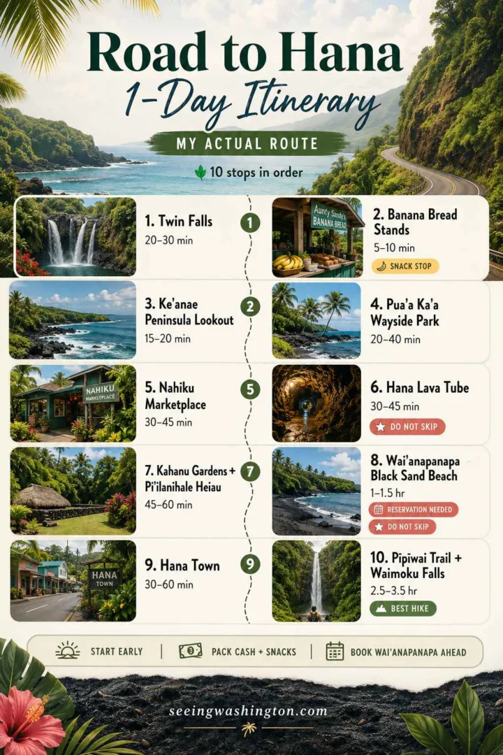
Road to Hana 1-Day Itinerary: My Actual Route
This is the exact itinerary I drove — every stop in order, with honest notes on what was worth the time and what I’d skip on a second trip.
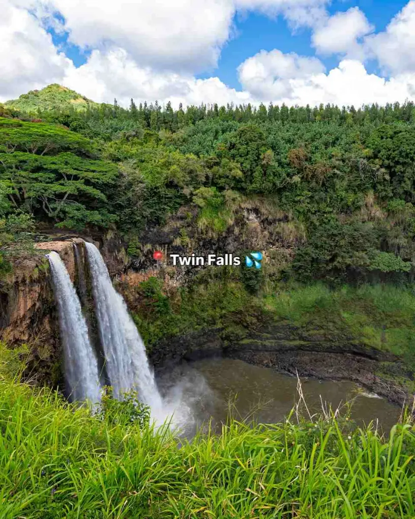
Stop 1: Twin Falls (Mile Marker 2) — 15 Minutes From Kahului
Twin Falls is the first waterfall stop on the Road to Hana and the most accessible. The trail from the parking area to the falls is about 0.5 miles through a canopy of tropical trees. The falls themselves are modest — 2 parallel cascades into a shallow pool — but they set the tone for the drive.
I almost skipped Twin Falls because I’d read it was “too touristy.” It is touristy. But the waterfall is real, the trail is short, and starting the day with your feet in a jungle pool puts you in the right headspace for the next 60 miles.
Time needed: 20–30 minutes Facilities: Parking area, fruit stand, public restrooms
Stop 2: Banana Bread Stands (Mile Markers 10–16)
Banana bread stands line the Road to Hana between mile markers 10 and 16, and they are not optional. The banana bread on the Hana Highway is made fresh daily at small family-run roadside stalls, and it’s some of the best baked goods I’ve ever eaten — dense, sweet, still warm when you pick it up.
I stopped at the Aunty Sandy’s stand near Ke’anae and again at a smaller unmarked stand near mile marker 13. Both were excellent. Buy a loaf at the first stand you see, if it’s freshly baked and warm. Don’t wait for “a better one” — mango stand secrets and banana bread availability change by the hour, and popular stalls sell out by noon.
Time needed: 5–10 minutes per stop Cost: $5–8 per loaf
Stop 3: Ke’anae Peninsula Lookout (Mile Marker 17)
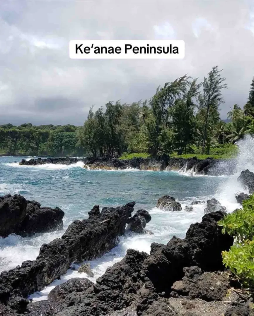
Ke’anae Peninsula is a flat lava rock peninsula jutting into the ocean with taro patch views, crashing waves, and a small community that’s been farming taro for generations. The lookout sits just off the highway and gives a wide coastal view that’s among the best on the entire Road to Hana.
The taro fields at Ke’anae are one of the oldest continuously farmed agricultural sites in Maui. I spent 15 minutes at the overlook just watching the waves hit the lava rock shoreline. Coastal cliff pullouts like this one are easy to pass by in a rush — don’t.
Time needed: 15–20 minutes
Stop 4: Pua’a Ka’a Wayside Park (Mile Marker 22.5)
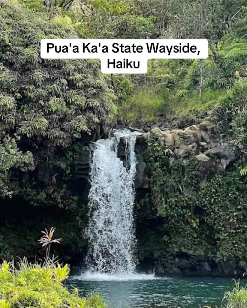
Pua’a Ka’a Wayside Park is a roadside state park with waterfalls, a small pool, public restrooms, and a picnic area — all within 100 yards of the parking area. This is the most convenient waterfall stop on the Road to Hana for anyone who doesn’t want a long hike.
The waterfalls at Pua’a Ka’a are modest in height but consistent in flow. The pool at the base is deep enough for a quick dip. The park has public restrooms — worth noting because restroom access on the Hana Highway is limited. I used Pua’a Ka’a as my mid-drive lunch stop with food I’d packed that morning.
Time needed: 20–40 minutes Facilities: Public restrooms, picnic area, parking area
Stop 5: Nahiku Marketplace (Mile Marker 29)
Nahiku Marketplace is a small collection of food stalls and vendors set back from the highway on a short side road. The marketplace sells island style tacos, kalua pork plates, coconut candy, smoothies, organic fruit, and hotdogs — and the quality is better than the setting suggests.
I ordered kalua pork tacos and a lilikoi smoothie and ate them sitting on a picnic bench surrounded by tropical trees. Nahiku Marketplace food is the best roadside meal on the Hana Highway, and the stop also has a souvenir shop for anyone collecting road trip gifts. HanaStyle Coconut Candy sold at Nahiku is handmade and genuinely good — I brought 3 bags home to Seattle.
Time needed: 30–45 minutes Facilities: Food stalls, restrooms, parking area
Stop 6: Hana Lava Tube (Mile Marker 31)
Hāna Lava Tube (also called Ka’eleku Caverns) is a self-guided underground lava tube tour through a volcanic cave system formed by ancient lava flows. The tube is approximately 2/3 of a mile long, and visitors walk through it with flashlights provided at the entrance.
The temperature inside the lava tube drops immediately — cool, dark, and silent. The lava rock formations include stalactites, shelves, and color variations from mineral deposits. I expected a quick novelty stop and ended up spending 45 minutes underground. The Hana Lava Tube is one of the most unique experiences on the entire Road to Hana and one of the stops I tell people not to skip.
Time needed: 30–45 minutes Cost: ~$15 per person (self-guided tours) Facilities: Parking area, small gift shop
Stop 7: Kahanu Gardens and Pi’ilanihale Heiau (Near Mile Marker 31)
Kahanu Gardens is a National Tropical Botanical Garden site featuring one of the largest collections of breadfruit trees in the world and the Pi’ilanihale Heiau — the largest ancient Hawaiian temple (heiau) in the state.
Pi’ilanihale Heiau is a massive stone platform structure built between the 14th and 18th centuries, and standing in front of it gave me a sense of scale that photographs don’t communicate. The garden trails take 45–60 minutes and pass through vanilla orchid plantings, coconut groves, and ethnobotanical collections that tell the story of Polynesian agricultural migration.
Time needed: 45 minutes–1 hour Cost: ~$10 per person
Stop 8: Wai’ānapanapa State Park — Black Sand Beach (Mile Marker 32)
Wai’ānapanapa State Park is home to Pailoa Beach — Maui’s most famous black sand beach — and one of the most photographed locations on the Road to Hana. The black sand is actually volcanic rock ground into fine grains by centuries of wave action, and the contrast between the jet-black shore, white surf, and green jungle behind it is genuinely striking.
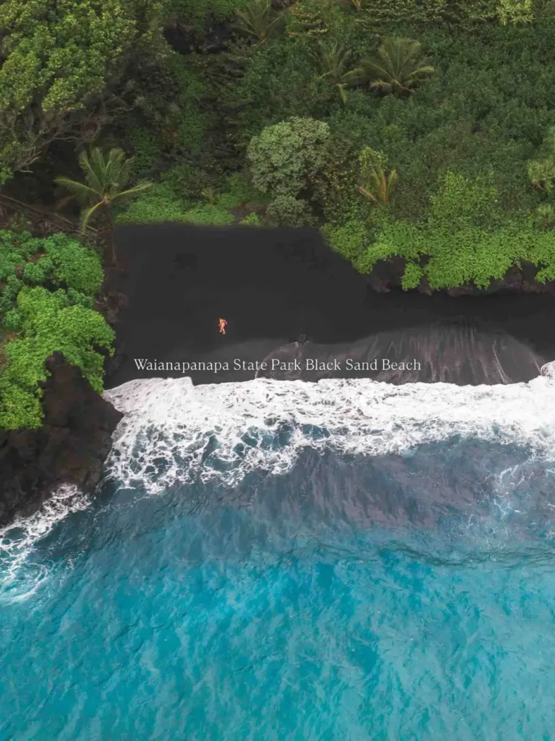
The park also includes a blowhole, sea caves, a short coastal trail, and ancient fishpond stops along the shoreline. Sea arch photography from the cliff trail above Pailoa Beach gives you the angle that shows up in every Maui travel guide — and it’s legitimate.
Wai’ānapanapa State Park requires a reservation for entry. Book online through the Hawaii DLNR reservation system before your trip. Reservations fill for popular morning time slots weeks in advance — I booked mine 3 weeks early and still only got an afternoon window.
Time needed: 1–1.5 hours Cost: $5 parking + $5 per person entry (non-residents) Facilities: Public restrooms, parking area, picnic area
Stop 9: Hana Town (Mile Marker 34)
Hana Town is the end point of the Hana Highway — a small, quiet community of roughly 1,200 residents that feels completely disconnected from the resort side of Maui. Hana Town has a general store, Hana Farms Roadside Stand (organic fruit, smoothies, mac ‘n cheese, and baked goods), a small bay, and the Hana Airport — a tiny regional airstrip.
Hana Town is not a tourist destination in the traditional sense. There’s no strip of shops, no resort infrastructure, no nightlife. It’s a real Hawaiian community that happens to sit at the end of a famous road. I found that honesty refreshing after 30+ miles of waterfalls and lookouts. Sit at Hana Bay, eat a plate from Hana Farms, and let the pace slow down before deciding whether to continue past Hana or turn back.
Time needed: 30 minutes–1 hour
Stop 10: Pīpīwai Trail, ‘Ohe’o Gulch, and Waimoku Falls (Past Hana — Mile Marker 42)
The Pīpīwai Trail is the best hike on the Road to Hana — a 4-mile round trip trail through dense rainforest, a towering bamboo forest, and ending at Waimoku Falls, a 400-foot waterfall that drops down a sheer rock face into a boulder-strewn gorge.

Pīpīwai Trail starts at ‘Ohe’o Gulch (historically called the Seven Sacred Pools) inside Haleakalā National Park. The Seven Sacred Pools are a series of cascading freshwater pools connected by waterfalls that flow down to the ocean. Swimming in the pools is sometimes restricted due to flash floods and falling rocks — check current conditions at the park entrance.
The bamboo forest section of Pīpīwai Trail is the single most memorable stretch of trail I’ve ever hiked. Thousands of bamboo stalks rise 50+ feet overhead, and the sound of them clicking and creaking in the wind fills the entire forest. It’s the experience that made the Road to Hana trip for me — I stood in that bamboo forest for 10 minutes just listening.
Waimoku Falls view at the trail’s end is the payoff. The 400-foot waterfall is massive and powerful, especially after rain. Do not stand directly beneath Waimoku Falls — falling rocks are a real hazard, and the park posts warnings at the base.
Pīpīwai Trail requires Haleakalā National Park entry. The park fee is $30 per vehicle (valid for 3 days). Cash or card accepted at the gate.
Time needed: 2.5–3.5 hours for the full hike Cost: $30 park entry per vehicle Facilities: Public restrooms at ‘Ohe’o Gulch trailhead, parking area
Road to Hana 2-Day Itinerary
A 2-day Road to Hana itinerary splits the drive into manageable halves and eliminates the exhaustion of driving 128 miles of winding road in a single day.
Day 1 — Kahului to Hana Town (Stops 1–9): Leave by 8:00 AM. Stop at Twin Falls, banana bread stands, Ke’anae, Pua’a Ka’a Wayside Park, Nahiku Marketplace, Hana Lava Tube, Kahanu Gardens, Wai’ānapanapa State Park, and Hana Town. Stay overnight in Hana (limited lodging — book early).
Day 2 — Hana to Pīpīwai Trail and Return: Drive past Hana to ‘Ohe’o Gulch and hike Pīpīwai Trail in the morning. Return via the Hana Highway or continue the loop past Hana on the backside road (partially unpaved — check road conditions and rental car restrictions before attempting).
A 2-day Road to Hana trip removes the pressure that makes the 1-day version stressful. I did the 1-day version and regretted not having a second morning at Pīpīwai Trail without watching the clock.
Is the Road to Hana Dangerous?
The Road to Hana is not dangerous for attentive, sober drivers who respect the road conditions. The Hana Highway has 620 curves and 46 one-lane bridges across 64 miles, which requires consistent attention and controlled speed (15–25 mph for most sections).
4 real hazards on the Road to Hana:
- One-lane bridge etiquette — yield to oncoming traffic already on the bridge; wait your turn. Ignoring one-lane bridge etiquette causes most of the close calls on the Hana Highway.
- Flash floods — heavy rain fills streams and waterfalls rapidly; creek crossings and waterfall pools can become dangerous within minutes. Check weather conditions before hiking any waterfall trail.
- Falling rocks — rockfall zones are marked along the highway. Avoid stopping beneath cliff overhangs, and heed all falling rock warnings at trailheads.
- Driver fatigue — 128 miles of curves in a single day exhausts concentration. The return drive in the afternoon is more dangerous than the morning drive out because drivers are tired. Pull over and rest, if you feel your focus slipping on the return.
Road to Hana conditions in 2025: Sections of the Hana Highway close periodically for maintenance, landslide clearing, and weather events. Check the Maui County road closure updates before departing. Road to Hana closure notifications appear on the Maui County website and local Maui news outlets.
Road to Hana Car Rental Tips
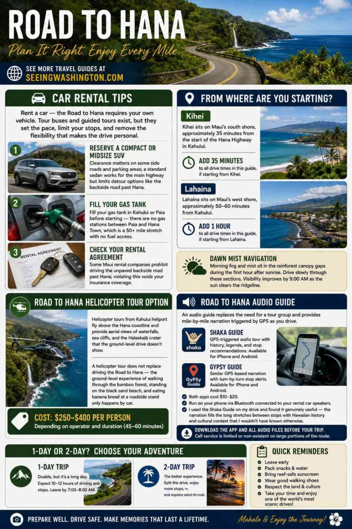
Rent a car — the Road to Hana requires your own vehicle. Tour buses and guided tours exist, but they set the pace, limit your stops, and remove the flexibility that makes the drive personal.
3 Road to Hana car rental tips:
- Reserve a compact or midsize SUV — clearance matters on some side roads and parking areas; a standard sedan works for the main highway but limits detour options like the backside road past Hana
- Fill your gas tank in Kahului or Paia before starting — there are no gas stations between Paia and Hana Town, which is a 50+ mile stretch with no fuel access
- Check your rental agreement for road restrictions — some Maui rental companies prohibit driving the unpaved backside road past Hana; violating this voids your insurance coverage
Road to Hana From Kihei vs. From Lahaina
Road to Hana from Kihei: Kihei sits on Maui’s south shore, approximately 35 minutes from the start of the Hana Highway in Kahului. Add 35 minutes to all drive times in this guide, if starting from Kihei.
Road to Hana from Lahaina: Lahaina sits on Maui’s west shore, approximately 50–60 minutes from Kahului. Add 1 hour to all drive times, if starting from Lahaina. Drivers from Lahaina should leave by 6:00–6:30 AM to reach the first Road to Hana stops by 8:00 AM.
Dawn mist navigation on the Hana Highway is real — morning fog and mist sit in the rainforest canopy gaps during the first hour after sunrise. Drive slowly through these sections. Visibility improves by 9:00 AM as the sun clears the ridgeline.
Road to Hana Audio Guide
A Road to Hana audio guide replaces the need for a tour group and provides mile-by-mile narration triggered by GPS as you drive. The 2 most popular Road to Hana audio guide apps are:
- Shaka Guide — GPS-triggered audio tour with history, legends, and stop recommendations; available for iPhone and Android
- GyPSy Guide — similar GPS-based narration with turn-by-turn stop alerts
Both apps cost $10–20 and run on your phone via Bluetooth connected to your rental car speakers. I used the Shaka Guide on my drive and found it genuinely useful — the narration fills the long stretches between stops with Hawaiian history and cultural context that I wouldn’t have known otherwise.
Download the app and all audio files before leaving your hotel — cell service drops to zero in multiple sections of the Hana Highway.
Road to Hana Helicopter Tour Option
Road to Hana helicopter tours fly above the Hana coastline and provide aerial views of waterfalls, sea cliffs, and the Haleakalā crater that the ground-level drive doesn’t show. Helicopter tours from Kahului heliport cover the Hana coastline in approximately 45–60 minutes.
A helicopter tour does not replace driving the Road to Hana — the ground-level experience of walking through the bamboo forest, standing on the black sand beach, and eating banana bread at a roadside stand only happens by car. But a helicopter flight adds perspective that the road itself can’t provide, and the aerial views of hidden waterfall detours and coastal cliff formations are worth the cost for anyone with the budget.
Cost: $250–400 per person depending on operator and duration

What to Pack for the Road to Hana
9 items to pack for the Road to Hana based on what I actually used and what I wished I’d brought:
- Reef-safe sunscreen — required by Maui county law for ocean and pool swimming
- Water shoes — waterfall pools and black sand beaches have sharp volcanic rock underfoot
- Rain jacket — the Hana Highway passes through active rainforest; brief showers hit randomly
- 2+ liters of water per person — no water refill stations between Paia and Hana Town
- Packed lunch and snacks — food stops exist but are spaced far apart; mountain apple snacks and banana bread fill the gaps
- Cash — several roadside stands and smaller stops only accept cash
- Phone charger / portable battery — GPS audio guides drain phone battery fast
- Towel — for waterfall swimming, black sand beach, and general wet-everything situations
- Motion sickness medication — take it before the drive starts, if you’re prone to car sickness; 620 curves is not an exaggeration
A Final Word From a Seattle Blogger Who Flew to Maui for This Road
The Road to Hana earned its reputation. I flew from Seattle to Maui primarily to drive this road, and it delivered on every level I’d hoped for — the bamboo forest on the Pīpīwai Trail, the black sand at Wai’ānapanapa, the sound of waterfalls appearing and disappearing around every curve.
The drive is long. The curves are relentless. The return trip in the afternoon is tiring in a way that the morning outbound drive isn’t. And none of that matters once you’re standing at the base of Waimoku Falls watching 400 feet of water drop out of the rainforest canopy.
Start early. Pack food. Download the audio guide. Book your Wai’ānapanapa reservation weeks ahead. And drive slowly — the Road to Hana rewards patience more than speed.


